lundi 29 novembre 2021

Fly fishing (sort of) newbie looking for some guidance

I am experienced saltwater fisherman who is now a year round North Country resident. My experience with reading saltwater flats, big flies, and 8 wt. rods is not very useful here so I feel like I am starting over from scratch. I am looking for some help with transitioning to cold water fishing, fly tying, etc. Also, are there any local fishing clubs where people gather to share their experience?

Thanks in advance for any advice.


vendredi 19 novembre 2021

Whiteface Highway

The highway has been skiable for a few weeks now, but yesterday's (Thursday 11/18) warm weather stripped most of the snow off the road. Today, however, a series of snow showers produced 1/2" of dense snow at the toll house, grading to about an inch above 3,500 feet. Some icy base left above 3,500', but skiable to the Castle.


jeudi 18 novembre 2021

Landlocked Salmon Primer

There's been plenty of talk in the other thread about landlocks so I thought I would throw up some pictures from my short trips in the last couple weeks and some history/tactics.

DEC stocks landlocks in a number of interior ADK lakes, they are listed in the stocking list and also in the 'places to fish' county breakdown for Region 5. They are listed below 'splake' so it's likely Glen didn't read past that point to see where the good LLS lakes are. These interior lakes are almost exclusively put, grow, and take lakes so I don't feel too much guilt about talking about this fishery. DEC also stocks 24-30 inch breeder salmon into select interior lakes during november for a purely put and take fishery. Most of these fish are snatched up by icefisherman but they can provide some exciting sport if you can find them before ice-on. There are some self sustaining populations in a couple lakes where they were introduced and I've seen some wild fish in streams that feed larger lakes but these are few and far between.

Personally, I like going after these fish in the fall. They come in close to shore for extended periods of time and enter just about any lake feeder stream with adequate flow. With NY's new year round stream fishing regulations, runs of these fish are now in play for catch and release fishing. NOTE: If you do this kind of fishing you will inevitably run into spawning fish. They are easy to spot and can be avoided even though it is not illegal to fish for them. If they are moving to spawn or have finished and are dropping back, they can be targeted with streamers and are quite aggresive toward them. I sense that this fishery is underutilized because you're not likely to run into trophy fish like you'd find in lake ontario or finger lake tribs. Most fish will run from 15-20 inches and depending on the lake system you could find consistent mid 20's up to around 30 inches. They fight hard regardless of their size and the solitude of the Adirondacks in late fall is usually preferable to the great lakes circus. I've seen them run into streams from late August all the way until the first week of January. In the last decade, fish have been incrementally later in their trip to the shallows presumably due to temperature. The fish I caught in the last couple weeks have been a mixture of spawned out fish and pre-spawn fish staging off tributaries. The large female below was staged in a deep hole just off the mouth of a trib and was released quickly after a photo on the net. Another cool way to fish these fish is to anchor up in a boat and cast flies to them post spawn, I have had some spectacular number days doing this. I usually fish a floating line with varying length leader for depth. Best flies include clousers, wooly buggers, picket pins, traditional streamers, mickey finns, and hares ears. I think any trout fly would probably work but something with orange color seems to be a key. Landlocks also love to exit lakes and can also be found in their outlets often far down stream of where they've been stocked. I've personally caught fish that have travelled 10-15 water miles from their stocked lake. I've heard of others that have travelled even longer distances.

So hopefully this might give some people the itch to fish for these worthwhile gamefish this fall (plus bonus brook trout). I'll keep going until the lakes get pretty iced up and then transition to steelhead.

Attached Images
File Type: jpg IMG_3241.jpg (75.5 KB)
File Type: jpg IMG_3246.jpg (40.1 KB)
File Type: jpg IMG_3248.jpg (48.6 KB)
File Type: jpg IMG_3257.jpg (74.4 KB)
File Type: jpg IMG_3261.jpg (44.9 KB)
File Type: jpg IMG_3243.jpg (30.4 KB)


Local Rainbow

From my home waters. Her name is Gertrude and she's been eating well.

Attached Images
File Type: jpg Fall Bow.jpg (70.9 KB)


mardi 16 novembre 2021

Indian River Drawdown

The New York State Department of Environmental Conservation (DEC) announced today that Central Rivers Power, licensee of the Theresa Hydroelectric Project (FERC No. 4486), is overseeing a gradual drawdown of the Indian River to allow for replacement of a hydraulically operated 17.5-foot-high spillway gate.

The drawdown will take place over several days to allow for the protection of aquatic life and will last approximately four months.

https://www.dec.ny.gov/press/124196.html


lundi 15 novembre 2021

Sugarloaf mountain in the Town of Willsboro

As a member of CATS (the Champlain Area Trail System), I got an email that they were creating a new trail to Sugarloaf mountain on Saturday, 11/13. I was disappointed that I was tied up that day and, it was raining heavily then, so I didn't know if the event would occur. However, this trail isn't exactly new, because it does appear on my GAIA OpenStreetMap layer, so yesterday my wife and I decided to try out this trail. We got to what probably will be the trailhead (there were three cars parked along the side of the road) and started walking. We soon met a group of 4 or 5 people coming down and were warned that some of the trail is on private property so watch out for hunters. The first part of this route is actually on Carver Road, a public gravel road which is also a snowmobile trail. We got to the place where our route left the road, as did the snowmobile route and we followed it. It is well marked, with several signs saying "sugarloaf" (or "'loaf") and two labeled "Fresno". We soon got to a clearing and our route left the snowmobile route and started to climb. It was fairly hard to follow in places, requiring 'whacking, but periodically we would see a ribbon, so we proceeded to the top, which has quite a nice view of the "Reber Valley", as well as Lake Champlain and a distant view of Giant and other High Peaks.
There were many shagbark Hickory trees near the summit!
PS - saw no evidence of recent trail building.

Attached Images
File Type: jpg Fresno Trail2.jpg (66.8 KB)


How big is your world?

I really don't know much about this app, but you do have to sign up. It's free and no payment info required.

Google maps does not have the capability to make a locus of points at a constant time (per mode of travel) from a fixed point. It can connect single points and do the calculation but this is much more interesting.

If you are looking to relocate, this might be an interesting exercise. It's also nice to compare an area to your current location and see what is in your travel sphere, and how much of that is stuff you value.

I really don't like to travel more than two hours one way without an overnight stay and I rarely do and don't prefer to travel more than 6 hours in a day. It's pretty cool to set up sets of time intervals to local location access.

I'm assuming it uses speed limits of the access roads to determine the max distance in a time. I've checked it against a few known points and it seems right in the ball park - within a few minutes of what I get in real life travel.

Attached Images
File Type: jpg Untitled presentation (5).jpg (60.2 KB)


dimanche 14 novembre 2021

Huckleberry Mtn - Johnsburg 11/14/21

We hiked Huckleberry Mountain in Johnsburg from Johnsburg Rd. Our approach was across the property that NY state purchased from the Open Space Institute earlier this year. The trip began on old logging roads and then a series of open rock ledges. We hit some pretty thick woods as we approached the top of the ridge. There are extensive areas on the upper part of the mountain with lots of relatively new growth, downed trees, and evidence of past forest fires. The footing was pretty slippery with the recent rain and snow. It was great fun to explore this beautiful area looking down on the high valley between Crane and Huckleberry and views up to the snow on Crane. We will definitely be back to do some more exploring.

Attached Images
File Type: jpg IMG_4565.jpg (144.6 KB)


samedi 13 novembre 2021

Unidentified fish on Lower Saranac Lake

Hey guys, I am hoping to find someone here is who is familiar with the fishing on Lower Saranac Lake.

I just got back from spending a week there in the hot tent catching some massive Northern Pike, ended up catching 18 total across the 7 days. There was one particular hookup though, that has left me very confused and was hoping to get some insight from someone who fishes that water more often.

On 3 day I was fishing my usual spot to catch Pike and instantly knew I was hooked into something different when this grabbed my line. It felt like it was fighting me like a Trout, but I did not think that possible in Pike infested water. Sure enough though, I got my fish to the surface and I was surprised to see it was what I thought to be a huge Lake Trout! I had my GoPro running, but this fish was so big I could not get it into my collapsible net and before I got get a good grip it managed to shake my hook out right next to the boat. The thing is, I got a clear look at it and have started to doubt it was a Lake Trout. The first thing going against it being a Laker, is that apparently there are no Lake Trout in Lower Saranac. It definitely had the classic Trout profile, a silver/grey coloring to its body, and diamond looking spotting on its body. There was absolutely no pink streak across body that would make me think it was a Rainbow Trout.

Any ideas on what this could have been? I really wish I had managed to get a glimpse of it on the GoPro.


vendredi 12 novembre 2021

Chimney Rock-Tioga State Forest

https://endlessmountains.wordpress.c...-state-forest/

An enjoyable hike to a great view over Pine Creek. When it has water, Bull Run has several small falls. A diverse hike with hemlocks, meadows, and saplings from a fire many years ago. One of many fine trails to check out in the Pine Creek region.


https://www.instagram.com/p/CV-bn4jL..._web_copy_link


https://www.instagram.com/p/CWAD4H3A..._web_copy_link


Birch Trail-Tioga State Forest

https://endlessmountains.wordpress.c...-state-forest/

An isolated, little known trail deep in the Tioga State Forest with views and unique rock formations along a narrow ridge.


https://www.instagram.com/p/CV9N8qAt..._web_copy_link


https://www.instagram.com/p/CV9O6HKt..._web_copy_link


mardi 9 novembre 2021

Hickory in the park

Here we go again... :D

Do any exist in the north country?

Maps for common species in the rest of NY show them absent in Tug Hill and Adirondack regions.

Closely associated with Oaks (and the defunct American Chestnut) in growing habitat, this seems to be a thing. I'd assume they can hang in lower elevations, drier climate of the southwestern regions?

I've never once noticed one, but haven't done much looking.

In western FLR, from what I've seen not much or any mast from the Oaks this year, but the Hickory are producing some, if not abundant in some cases. I'd assume Hickory mast to be pretty important when the Oaks fail.

Having really taken notice of them this year, they have some of the best fall color really. Almost as good as maples.


lundi 8 novembre 2021

Not nearly Pine Lake

I had been packing slowly for weeks.
Had my snacks and meals dried for two weeks ahead.
Packed heavy, much heavier than usual, since I was rolling, not carrying.


I had planned to go on a Thursday and return home on Saturday, but the forecast was dismal. So I decided to delay, something I don't normally do.
Instead I committed to other stuff, and would leave on Sunday morning.
Since I was all packed, no reason to rush. I even went to the market with MDB before I left. BTW, those days that I didn't go, the weather was very nice.

So I get to Abenakee Lake later than I usually would, it was drizzling on and off. No problem, it's a slow drive in, the weather might clear up as I continue. Turn in on Chain Lakes South road, and drive past the Outer Gooley Club house...nothing left but an oversized parking lot. I continued on, past the next gate, since it's open to the public for big game season.
Park in the small lot, and load up the boat on my trusty RollEez wheels. It's sprinkling on and off, still no big deal, I have rain gear.
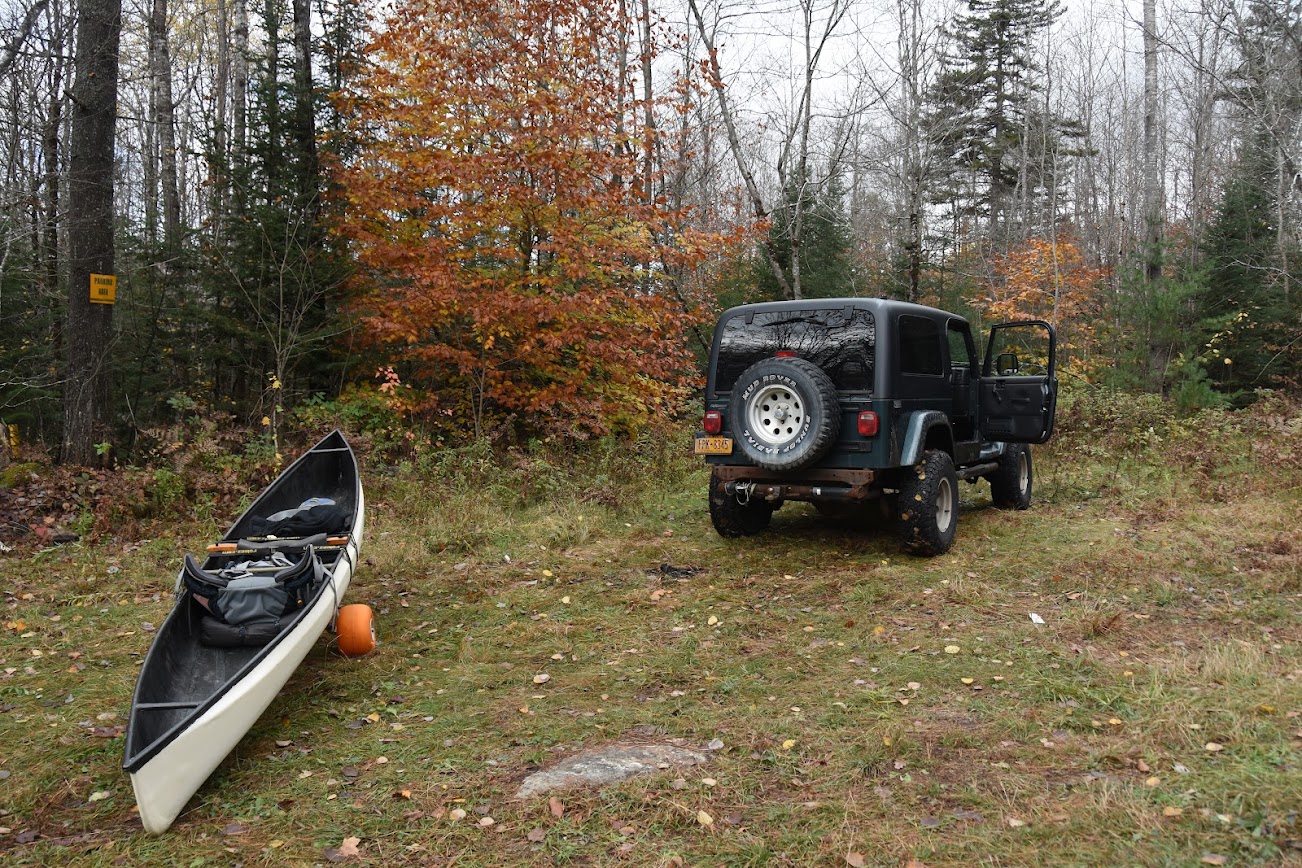


By now, it's like noon, but I'm only going in about 2.5 miles.
I get a bit past Mud Pond, and see this.


Beavers have flooded a good portion of the old road, still no big deal, I admire their skills. For the moment, the skies are dry, and other than a couple small game hunters at the sign in, I've seen no one. The old road is washed out a little, just before getting to the Cedar River. After I get to the bottom of the hill, it seems like my gear has tripled in weight!

I look at my trusty wheels and see this.


Yeah, see that dark hole, the one where a valve stem used to live?
At this point, the rain was back in earnest now. With one flat wheel, and about .9 miles to go, it's decision time.
Hmmm, with all my gear in the canoe, on one flat wheel the carrier frame drags along, plowing a furrow. Did I mention that I packed heavy?
I whittled a twig to jam into the hole where the valve used to be, and that keeps the tire from fully flattening. But, the wheel still can't support everything. So I shoulder my pack, oh yeah, it's heavy. Like 55 lbs, way heavy for me. The nearly empty canoe kind of rolls along...

At this point, my phone rings. Yup, there's service here. It's MDB, asking how things are going, she isn't thrilled with me going solo. Did I mention it's raining pretty hard now? She tells me the forecast is worse than when I left home. I reconsider, and decide to bail out on Pine Lake, I'll limp my way back out, maybe camp at Clear Pond.

So I drag my boat with my too heavy pack on my shoulders, it's slow going for sure.
I stow my gear back in the Jeep, put the boat back up on the racks, and head back towards the Clear Pond trail...DEC sign says it's only 0.3 miles.
I grab my camera and rain gear, and walk in to take a quick look. Well, not really quick, it's closer to .75 miles to the pond. And when I get there, it looks like this.


Not exactly inviting. By now, it's 3:30 PM, I'm beyond discouraged.
OK, I give up.
On the drive back out, next to Abenakee, there was a brief moment of sunshine, even though it was still raining hard.


Ok, maybe I'll swing by Indian Lake and see if I can grab a site there and salvage some sort of trip.


In retrospect:

Since I'm going solo, I should just leave when there's a window of better weather. No need to stick to any sort of schedule.

Don't pack heavy since I'm wheeling, I should pack light as I usually do.

Leave early in the day, even if it is a shorter drive.

Don't trust those 25 year old trusty wheels, even though I monitored the pressures for weeks before.

Well, I guess all the trips can't be ideal. I'll try again next spring, but come in from the north via the Chain Drain. It's about 7 miles that way, but at least I know the terrain and water.


Osprey Cresent Backpack

Xtra large. red backpack for sale. Very good to good condition, used on several extended backpacking trips including Northville Lake Placid trail. Selling for 125.00 and I can ship for the cost of shipping fee. It will make someone a great backpack.

Sent from my SAMSUNG-SM-G891A using Tapatalk


What a day

I know it's not a brook trout but it was a lot of fun had the whole Lake to myself

Attached Images
File Type: jpg Screenshot_20211107-120532_Gallery.jpg (121.8 KB)
File Type: jpg 20211107_104048.jpg (80.4 KB)


samedi 6 novembre 2021

Current conditions on the Bucktail Path and the Donut Hole Trail?

Calling Jeff Mitchell once again!

Has anyone here recently hiked any portions of either the Bucktail Path or the Donut Hole Trail in PA, and can comment on current trail conditions? I've heard that these two trails- the Bucktail Path especially- can be overgrown and not particularly well maintained. "Goat path" are the words I've heard used by several different sources to describe the Bucktail Path in particular.

A few friends and I are starting to plan a tentative week long backpacking trip for next early April as a follow-up to our Loyalsock Trail hike this past spring. We'll probably have somewhere around 5-7 full days to devote to hiking, and one option we're considering is to do a portion of the combined Bucktrail Path and Donut Hole Trail... the southern terminus of the BP is about 1-2 miles of road walking from the northern terminus of the DHT, so it wouldn't be too hard to link these two trails together.

Obviously, our timeframe probably does not give us not enough days to hike the combined 120 miles of both trails in a single trip, but one option we're considering is to hike half this trip, and the second half on a future trip (likely spring of 2023).

Also, on the plus side, early April would be early enough that the herbaceous growth wouldn't be out yet... so the tread should be easier to spot (and no stinging nettle yet, either).


vendredi 5 novembre 2021

Long Lake - July

I am looking to head out to Long Lake in July. While i have been paddling/camping the ADK's for 25 years, i have never camped on Long Lake. I will be going with a small group and prefer a lean to. We will be fishing quite alot while we are there. We like to try and be off the beaten path if we can. Anyone have a good reccommendation for a site?


mercredi 3 novembre 2021

Help with Tree ID

There's a particular Oak I've seen planted in a park that I cannot figure out.. It may not be a particular species but a defect... but there are at least 4 of them in this particular area.

As I mentioned they are in a man-made park so I wouldn't bet they are anything native. They are near a freeway (elevated) and I've noticed them for years because they just look so weird. I finally got a chance to walk over to them and look at one close. I didn't take a pic, perhaps I will but they may be devoid of leaves by the time I can do that.

Anyway, the leaves aren't anything special. They look like a white oak with very shallow lobes, much like the leaf of a chestnut oak, but perhaps a bit wider a more lobed than crenate. I know there's a big variation here within those two species from what I have seen. The general shape is ovate, about 4x2.5" or so on the lower branches.

The bark looks to me very reminiscent of bur oak. It's (mostly) parallel and deeply ridged, without many vertical breaks and very light grey on the tops of the ridges.

All those identifiers are not what bother me. It's the branching. It has very large branches which then stop at what are almost like nodes with 10's of very small branches protruding outward like a scrubby bush. The "nodes" occur at relatively far spaces and foliage only grows on those small "bushes" making the tree look very odd in that it has not a full, spreading crown (these trees are well spaced), but full spreading, thick branches (all with those pronounced ridges) with those small scrubby portions dotting the tree.

Perhaps these aren't special trees but are being harmed by the road pollution. I didn't spend enough time to look for an acorn, but perhaps I will, although I didn't see any on the tree I looked at closely.

There are a number of (what I believe are) bur oaks planted close by in another section of the park, away from the road. The leaves are slightly different but the bark looks similar. The bur oak had a number of different leaf variants that I could see that I believe correspond to the shapes of that species. I didn't find any acorns to confirm they are bur oak though.

At any rate, that other grove does not have that strange branching. The upper branches of the bur oaks looks like the other "ugly" trees but they all have much more dense, full crowns with lots of leaves and none of that weird, ugly bush branching.

I've searched a number of different references and I can't find anything regarding that weird branching, so perhaps it's an environmental impact.


mardi 2 novembre 2021

Another Nice Adirondack Northern Pike!

My girlfriend and I got out with the hot tent to Fourth Lake to do a short weekend trip in search of some Northern Pike. With the colder temps moving in we basically had the entire island and lake to ourselves. The views while paddling were spectacular and the Pike I ended up hooking into was a real fighter! Was great getting out there, even for a short one. The rest of my week will be making the final preparations for a longer trip I am taking at the end of this week. Going to be heading back out with the canoe and hot tent in search of more big Pike on a larger lake.

Full Imgur Gallery: https://imgur.com/gallery/bvVoala

YouTube Trip Video: https://youtu.be/llD6OB1D2CE


lundi 1 novembre 2021

Allen this weekend?

Would love to hear peoples' opinions of the likelihood of being able to do Allen this Friday with the water being so high.

Thank you. I appreciate it.