samedi 30 avril 2022

Lows Update

Hello all,

Wondering if anyone has any intel on the Whiney Loop to the Lower Dam, or any updates of the individual bodies of water that comprise it.

Looking to head out soon and greet the new crop of blackflies personally.

Thank you!


vendredi 29 avril 2022

Putnam Pond

Just got back from spending five nights in Schroon Lake at the Blue Ridge Motel. Decided to go the soft route and do day hikes into the area rather then the backpacking trip I originally planned. While I have backpacked into Pharaoh Lake four times, I never really explored the area. This trip took me to Clear, Heart, North, Little Rock, Rock and Berrymill. Wanted to climb Treadway, but it became clear to me that my dog Maggie's days of climbing mountains is probably past her now. Instead we kept on the level ground this trip. I saved Berrymill for last, not because I expected it to be special, but simply because it would make for a last hike and only be four miles so as to not tax my Maggie by the end of our stay. DAMN!!! While the trail is like most trails, certainly nothing out of the ordinary, I was blown away by the beautiful waterfall just prior to reaching Berrymill lean-to. It was beautiful. Then I approached Berrymill and instantly felt a connection that I never expected. It was beyond beautiful, it was breathtaking. I was instantly taken in by the lean-to's placement as well. I will be honest with you all, I haven't personally found a spot this beautiful outside of Colden Lake. Everyone has their own definition of beauty, so maybe this spot is "ok" to some, but all that matters is how I see it. I'm coming back in September to spend a few nights there. My Maggie can make this hike easily, and we won't need to climb any mountains to obtain views, because Berrymill has all the views either of us need.

Definitely enjoyed our other hikes, and visiting all those other ponds was something I have wanted to do for a very long time. I'd be lying if I didn't say I very much appreciated the many foot bridges that got us over the many streams in the area. I won't complain either that there are too many markers along the trail. Maybe it's my old age, but I was just fine with both of those. I am glad to report also that every lean-to we came to was very clean. Justin, you did a great job at Rock Pond, because it was still clean when Maggie and I got there.

On a sad note, my best hiking companion ever, Maggie, is slowing down quicker then I had hoped she would. Our backpack trip into Colden last year was very taxing on her, so I felt coming up and doing these hikes would allow her to both enjoy our time together, and not put a strain on herself. Turned out though that she was limping after each hike, even though we took it slow. Since she entered my life almost eight years ago, I haven't left the house without her probably 95% of the time. Even if I am only going up to the corner to get some milk, she is with me. Have had senior blood work done on her recently, and had multiple x-rays taken to see if they could figure out why she is limping. On a positive note, her joints are in great shape and my vet can't find anything that might be causing her to limp after our hikes. Unfortunately though, something isn't right. While we are out hiking (we have hiked 1000's of miles together), she doesn't display any discomfort, fatigue or anything that would indicate she isn't comfortable. This is just about the most stressing thing I am facing right now. I can't even begin to fathom what I would do if while she is pleading with me to take her, I might have to say you can't come for your own good. This is a heartbreaking moment in our lives together for me. On a strictly selfish note, though I am 71, I am fortunate that my joints and the rest of me are fine. Though I am slower then a turtle on the tougher trails, and 2000' foot of elevation gain will never come quickly for me, I can get the job done. But my window will be closing sooner rather then later. With Maggie slowing down much more rapidly then I am, I am at a complete loss as what I should do. I truly can't imagine not having her by my side, but I don't want to harm her either. When we come up to people on the trail, Maggie doesn't even look up at them. For her, it's the two of us and nothing else matters. I have my wife of course, but out on the trail, Maggie is all that matters to me.

jeudi 28 avril 2022

Japanese Knotweed

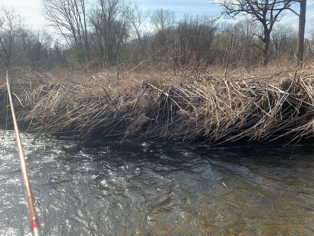
I know there are more pressing issues in the world today... Vile stuff - In the stream within walking distance of the house - it has mostly taken over the stream bank and chocked out the native vegetation. This time of year, the dead stalks from last year make walking difficult. It grows a couple of feet per week and in a month the new growth will make passage virtually impossible. Very tough to control and when established nearly futile to try to remove. A quick search of the literature proves the dire impact on invertebrates and fisheries ...


img hosting


Fickle Critters!

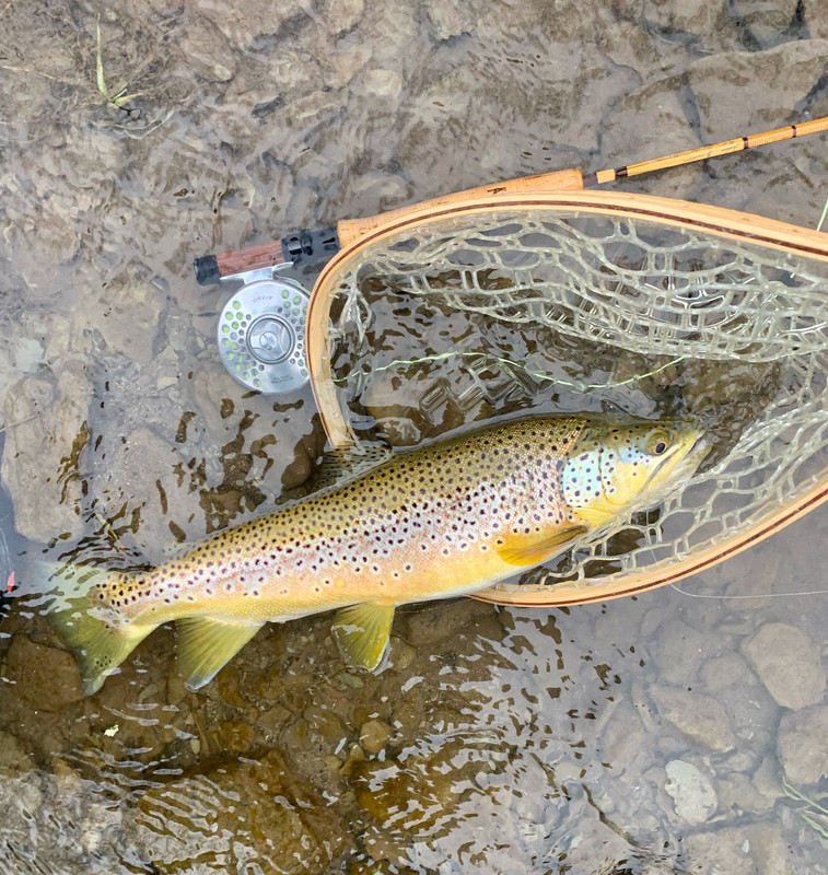
Had the chance this week to visit a local stream not too far removed from the Adirondacks ... it has had an extended season for numerous years and I have had good luck even in the winter when it isn?t locked in ice. Usually fishes very well this time of year. Tues one trout and a bunch of suckers... today nary a hit. Used a bamboo rod made in Plattsburgh by a gent named Andy Barr. The stick has had a few owners - The last on the west coast. Now back in use a bit closer to home...


First trip of the season

Heading up for some pond fishing. Unfortunately VTflyfish will be joining me. When I get back I'll try to post some pics but most of my brookies are too large for the camera to capture more than just the head or tail. Which do you prefer?


dimanche 24 avril 2022

Prompt to download chrome?

Anyone else getting a sketchy redirect to "update chrome" when they access this forum on chrome? Seems like maybe the forums have been compromised?


samedi 23 avril 2022

Gosnell Big Woods "Old Growth" Preserve

I took a short trip to this area yesterday to do some investigation on the area and learn more old growth in this area.

Here's a short description and location information:

https://www.geneseelandtrust.org/pub...nell-big-woods


This was not my first visit here, but I'll be quite honest my knowledge was much less the first time, and going back again, it's still quite lacking, but getting better.


What I noticed -

The area exhibits some so-called old growth characteristics such as:

1. Abundance of dead and downed wood. Most trees that were down were beech and hemlock although I saw some cherry.

2. All age classes of trees from very old to very young. I did not age anything although there were downed logs available to count. I found some info I'll link down below that did the heavy lifting for me there. Beech and hemlock confirmed to be up to 250 years old. There were a number of saplings around, mostly beech from what I saw. I did not see many seedlings but I did find one very new red maple seedling.

3. Dead standing snags. There were a number of these. Many beech, some ash (I believe - but dead) in the wet areas. But also a number of cherry and some hemlock.

4. Deep organic soils. This didn't exactly jibe. You aren't supposed to go off trail here, but I walked a little in the organic areas and they weren't all that deep. Perhaps this is a bit subjective. The base mineral soil was very sandy in most areas and likely deep loam.


I would say at least 3 out of 4 of those exist but the entire area is not consistent.


The "core" area where they have what's called out "lookout" is probably the oldest. It's largely, from what I could see, hemlock, beech and sweet birch (betula lenta). There was at least one red oak there, quite large, but probably no more than 150yo, and some other large trees that may have been tulip poplar (I need to go back with leaves or flowers). I found hickory nuts and walnuts on the ground in the vicinity but I really couldn't tell for certain where they came from. Other sources state old basswood, but I did not see those - perhaps they were further off-trail where I didn't venture.

As you walk along the trail you dip to a low spot where red maples start popping up and then quickly climb up a ridge - only about 30' or so in elevation, but the forest changes drastically. You start to notice cherry and sugar maples and quite a strong presence of red oak. Eventually you top out and the forest changes. It's not mainly beech and red oak but with scattered cherry and few maples, red and sugar. The sweet birch are still present but less abundant.

Here I found some interesting trees, quite large, which I think are cucumber magnolias. There's also a stand of tulip poplar here I read from another source, but I think they are off trail a bit.


Based on other sources - it's speculated that this region is not really all that old. Although I don't know, it may still be representative of this forest type in a drier soil. I'm not convinced that red oak isn't a major component of forests in this part of the world, particularly in elevated areas.

What I tended to notice was as the site was lower and more mesic (wetter) that there was more hemlock and some red maple as opposed to cherry and red oak on the higher ground.

I was a little surprised to see very little sugar maple though - I figure this would be more of a dominant component, but it really was not. There are a few very large, and likely old sugar maple here, but only a couple in a 100 acres. I only saw a handful more and they were much smaller.

Here's a link to a more scientific report. I'll post some pics in a bit:

http://ents-bbs.org/viewtopic.php?t=8143


vendredi 22 avril 2022

Putnum pond campground

Hello everyone, I am planning on a three day trip to pharaoh lake in a week and I have a question about parking. Will I be able to park at the boat launch at Putnum pond campground even though the campground is not open? I am assuming I can but wanted to make sure Before driving up. Planning on a loop from the trailhead for three days.
Thanks


jeudi 21 avril 2022

Slob

Just passing time until the pike walleye opener
Love fishing in the cold snowy days they always produce big fish

Attached Images
File Type: jpg Screenshot_20220420-073843_Messages.jpg (99.5 KB)


Tioga Point Campground Closed

I just received an email and a voicemail that my annual trip to Tioga Point with friends and family this year has been canceled, and will be closed through the end of the 2024 season. :cry:

Quote:

Please be advised: The campground, boat docks, and surrounding facility are being closed out of an abundance of caution for public safety. The facility will be close for the 2022 season and through the end of the 2024 season. If you have any questions, please feel free to contact us at 518-457-2500. We are sorry for any inconvenience this may cause, but appreciate your understanding.
I saw on facebook that it is a safety issue with cables in the lake.
Link to the DEC webpage: https://www.dec.ny.gov/outdoor/24499...02024%20season


lundi 18 avril 2022

Spring Turkeys '22

So, who is as pumped as I am for spring gobbler season? Not seeing a ton of birds but I do have a few gobblers located. Hunting some ag-lands this weekend with a youth. Looks promising, but I'm trying to get familiar with the farm. Hope everyone is seeing some birds.


dimanche 17 avril 2022

First brookie of the season

And a grand day out!

Attached Images
File Type: jpg Post.jpg (146.7 KB)


mardi 12 avril 2022

ice out

Some of them spots are opening like colby. Others still have ice but very very little. If i had to guess the next few days of warm and rain will open the rest. tight lines all and dont forget the new trout laws for NY.


lundi 11 avril 2022

Terror Lake

Has anyone been to Terror Lake recently? Looks interesting and challenging.


vendredi 8 avril 2022

Indian Lake area pond ice out

Please recommend a resource to determine when ice out is predicted on central Adirondack ponds. I know that the first week of May is the safest guess but hoping for sooner to shore fish.


How much is enough?

Public land, that is.


I set out to figure this out a few months back. Surprisingly difficult, actually. It's also a bit difficult to figure out given that some lands are not necessarily public, but protected in some way... so that perhaps asks the even bigger question, what is the goal of these lands?


My goal, I guess, was to figure out what the percentage is, by area. But really I was curious: what is the ideal amount?

I can tell you, I don't even think we're close... I'll also say that there are some sources on the internet that, as far as I can tell, are completely wrong. I found one that claims NY is up to 30% public. That's laughable - show me the math, because I can't find more than half of that land.

And beyond that, how much is "protected" land and how much is land that is managed in some way or another?

Turns out the New York National Heritage program has been tracking this, and they even have an interactive online map.

Using GIS software one can import the data and measure the area. I won't list the number just yet, but you might be surprised at how little it is. And many of these lands are not public access, many are easements, but those still have some level of protection against development, although many have some level of resource management.

That really sparked my thinking as to how much land should "preserved" and how much land should be managed? I think our calculus still shows it's very much skewed toward management.

I was thinking if we broke the land into 3 categories, we might ideally want to try to balance:

- Resource Management i.e. mining, forestry, ect.
- Agriculture
- Conservation

We could say an ideal model might equally divide area between the three - but I also left out housing and urban development, but I don't think that needs an equal amount of land area. Let's say 10% of NY for easy numbers. That gives us 30% of each of the others.

We were at once almost 80% deforested, but not all of that land was used for agriculture - I'd like to work some estimates but I think, at best, 30% of NY's land is really suitable for Ag.

About 60% of NY forested now, but not all of those lands are managed by the state or large timber companies, most are in the hand of small, private owners - which makes sense why the state has a program like the 480a Forest Tax Law to try to utilize resources effectively, and hopefully sustainable from small private owners.

But are these effective systems? It seems to me, by this method, we have far too much land in limbo that is either not being actively conserved or is not being managed properly for its resources.

We know some large clubs have lands that are conserved, but history has shown that these lands are often used for resource management - and there's no doubt, the state almost forces one into that position via taxes (and then rewards via 480a for timber management).

So my question are? How much land should be conserved? Should all of that land be publically accessible, or is conservation really the main goal? How can we more efficiently conserve lands that are currently not and should be (see something like the Riparian Opportunity Assessment)? Can we we shape more effectively what lands are used for resource management and agriculture to meet our needs as a state, and to fund our economy?


jeudi 7 avril 2022

Hemlock-Canadice State Forest

An article in in "Life in the Finger Lakes" led me to an interest in an obscure part of this state land.

It was said that there was some "old-growth" forest still left here and that there was a bit of unique history here. Through some other sources, I found out something that I knew, but didn't really know the entire picture. Apparently the city (of Rochester) used to own the land (this I knew) but they tried to secretly log this "old growth" and eventually wound up putting a 2-year moratorium on the logging. During that time something happened that I'm not exactly clear on, and I didn't bother to research, but the state acquired the land (as we know now as it currently still is held by the state).

I was curious what the protection status was of these trees, and what the situation is. I've yet to get out there, and I actually don't know exactly where the area is, so it may take me a few whacks, but as far as I can tell from the UMP for the area, those trees are off limits for harvest - mostly due to slope conditions and management for water quality considerations. I believe these UMP are written every 10 years, so every 10 years there *could* be consideration for changes in management and logging, so the trees are not really protected - not nearly in the sense as is forest preserve. But seen as how these are reservoirs for the city, and swimming is not even allowed, I don't see any huge threat to management which could jeopardize the the water supply (although arguably there are other issues that are not being addressed i.e. invasives).

I decided to contact the two professors at FLCC mentioned in the article. I didn't get much info, but based on what they say, the trees are not actually old growth (hence my use of quotations above). Dr. Gilman mentioned the site as being "persistent forest" rather than old-growth. I'm not sure exactly what that means, but I plan on checking into it. I know it's mainly oak forest, red and white oak. Perhaps what he means is it was selectively harvested for timber or firewood by nearby farms but was never heavily logged or cleared. Anyway, he told me I should contact the Ranger for the area for more info, which I have yet to do.

It's an interesting prospect, and something that maybe should have more protection than it currently has.


mercredi 6 avril 2022

70+ Standing Fire Towers Mapped

In my extensive research of New York's fire towers, I have found more than 70 standing towers scattered throughout the state. Many are open and climbable, some are open but not climbable, and others are not accessible to the public. I have mapped out these towers as best as I could here:

NEW YORK'S STANDING FIRE TOWERS

Feel free to suggest any additions or corrections to this map. This is a work-in-progress that will contain more detailed information in the future. I also plan to create a similar map for Pennsylvania's fire lookouts that will include these and more.

PRIMARY SOURCES:
http://nysffla.org/alphalist.html
https://www.dec.ny.gov/outdoor/100900.html
https://www.cnyhiking.com/NYStateFireTowers.htm
https://easternuslookouts.weebly.com/new-york.html


lundi 4 avril 2022

Rab Xenon 2.0 vs. Xenon

Product Tested: Rab Men's Xenon 2.0 Synthetic Insulated Hooded Jacket for Hiking, Climbing, and Skiing - Anthracite/Graphene - Medium

The Xenon 2.0 became available summer 2021

Price paid, where purchased: Amazon, $180

Size/Weight: 387g/13.6oz (Size M)

Similar products tried: Original Rab Zenon

How long/where tested: I used the Zenon 2.0 on a hike of Burroughs Range in the Catskills in subfreezing temperatures April 2. The insulation is similar in bulkiness and warmth to the original. It performed well for last peak as sun was getting low and hike back to Parking area in early evening.

Rating 1 to 5: 4

Summary: I purchased this jacket after having to retire the original model due to a faulty main zipper. I got almost 10 years of heavy use out of the original jacket, so no complaint there. The new model now uses YKK zippers, so hopefully this issue does not present itself again.
I notice a few things different with the 2.0. First the packable chest pocket was moved to the inside. The pocket is smaller now, and packing the jacket into the pocket is much more difficult that the previous model.
On the inside of the collar, the previous model had a fleece material that was soft. The 2.0 no longer has this and has shell material on the inside of collar. Not the end of the world, especially with beard or goatee, but worth mentioning.
There are no longer 2 points for cinching the elastic cord at the waist line. This was reduced to just one side.
The hood is smaller. It fits much better without helmet. However I don't think my ski helmet will fit under the hood in the 2.0. Again not a deal breaker, but worth mentioning.
Quilted sheet insulation over torso is new for this model. It is purported by Rab for "breathability". Jury is still out on this.
Overall its a great jacket for the money, and I would recommend to a friend.

https://rab.equipment/us/xenon-2-0-jacket


What are you wearing with your float tube fins?

Hi guys, I have a question and some time has passed since I last float tubed so I thought it would be good to get some new input...

What are you wearing over your stocking foot waders with your kicking fins? I have used a light weight water shoe with a plastic sole and then switched to Croc's based on feedback on here about 5 or 6 years ago.

Has anyone discovered anything new and improved to wear in your fins that is light for packing or are Croc's still the preference?

I am getting everything out and organized and wanted to check. I see Orvis has a lightweight shoe that doubles as a hiking shoe.

Input is appreciated... Thanks.
Stillhunter


dimanche 3 avril 2022

leanto/bridges ages?

Can anyone point me in the direction of some data on the ages of some of the backcountry points of interest? Looking for original built dates of leantos and bridges. I figure there has to be a database of this, but cant come up with anything via google. I figured the nys gis would have the information, but can quite figure out how to navigate to get what i want.

Thanks in advance


Janacks Landing to Cowhorn Pond

Good morning,

I am wondering if anyone has portaged a canoe from Janacks landing to the various ponds east (Glasby, Cat Mt. pond, Cowhorn, Bassout)? Is it doable with 5 days gear and a canoe? Would I be able to fill 5 days going this route?

I completed the Cranberry 50 years ago, but I dont recall the terrain through that area, with regards to portaging (I was just a hiker then).

Anyway, Cowhorn pond, and Olmstead, have always made an impression on me, and I would love to be able to paddle and hike my way around the 5 ponds area, without having to venture too far north into Cranberry lakes' motor boats.

Also, if its doable. I wouldnt mind finding a way to Indian Mt.

Thank you in advance.


samedi 2 avril 2022

What are your big trip plans for 2022?

Well, now we've maybe seen some light at the end of the pandemic tunnel, only maybe to have added back the cold war, what are your burning desires... in terms of adventures (please spare anything else)?


I've completely shifted focus from actually going anywhere to going somewhere and staying for a few days. I haven't actually been able to do any of this yet, but I have a number of places I want to go "hang out" at for a few days and really whack around a couple spots and check some things out - mostly nerdy tree and bug stuff, but also probably not places many people really want to go stumble around either. In all instances there are nice spots to camp AFIK and I'd utilize these whilst doing short day excursions from there. I won't bore too much more with my list, but I posted a good deal of it in this thread:

https://www.adkforum.com/showthread....ght=old+growth

There's also a number of remote beaver habitat I'd like to add on there, but I think I'll really need to up my game for that one... maybe even carry some waders :cool:


vendredi 1 avril 2022

Spiny water flea, an invasive zooplankton species

Anyone have knowledge of the Spiny Water Flea?

https://www.dec.ny.gov/outdoor/23892.html


What if...

I'm looking at the current geopolitical climate (the war) and wondering about what would happen if we had a nuclear strike in the NE USA. I think the pandemic has enlightened many of us to the possibility that things very unlikely to happen, can in fact, actually happen.

How to think about this? On one extreme you have the preppers, on the other extreme people that go about their life as if it won't happen. I find myself somewhere in the middle. Being the boy scout that I am, I'm wondering what to do now to prepare for that (hopefully never occuring) situation.

I find it interesting how the pandemic has inched us closer in preparation to a disaster scenario. Who would think there would be a run on TP. But now I find myself stocking more of the things I use. I also realize that I'm not into stocking things I don't routinely use like survival rations. I think to myself, What else?

As outdoor people on this forum, I believe we are far better equipped to handle disasters through skills such as making shelter, purifying water, even procuring food; and self sufficiency mindset. But these outdoor based skills are usually used in the outdoors. And what if everyone heads to, or wants to head to, the outdoors (read Adirondacks)? I doubt the local IGA in the Adirondacks could support a more than 100% increase in demand.

So stocking gas for a great escape might only seem necessary if you are close to or downwind of a target. Plattsburg?

If you are into what if scenario planning, I welcome your thoughts?


ALC Land Transfer

Amazing news! The infamous Adirondack League Club has donated ALL of its holdings to NYS. Still no news on when this will be open to the public, but maybe as soon as this summer!

Woody Harrelson, a famous member of the club, was instrumental in helping promote this land be given to the people of New York and kept "forever wild". He doesn't plan on giving up his fishing honey holes though ;)

Press release:

ALC Land Transfer